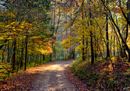
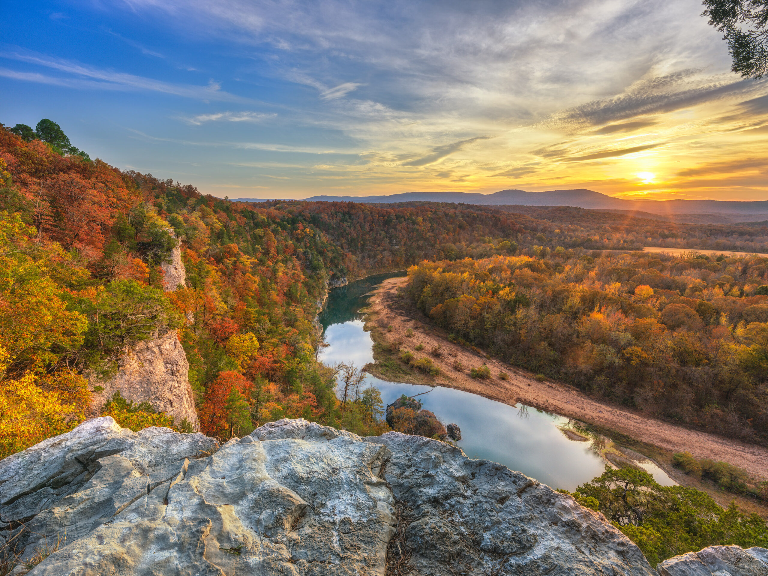
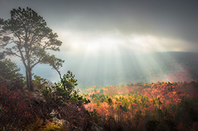
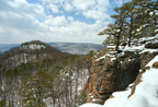
09/25/13 Featured Arkansas Photography–A quick preview of things to come, Fall scene on the Buffalo River sunrise over Bee Bluff
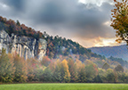

Sunrise over Bee Bluff on the Buffalo River–Click on image for a larger view
Taken with a Canon 5D MKII, Canon 24-70 lens @ F8 24mm, iso 200, bracketed exposures for final image. The Buffalo River has to hold some of the best photographic opportunities in Arkansas, especially in the fall. This shot was taken in 2011 but it’s a great example of what you can expect on the Buffalo. Here you will find almost every tree species that the state has and each one will have a unique fall color, along with the short leaf pines. In this shot you can see a row of sweet gums and maples along the lower part of the bluff and in the background on Bee bluff the oak and hickory trees are making their presence noted also. Fall in Arkansas can be glorious and on the Buffalo tends to peak sometime around mid October. I feel that this year since we have had such a long dry spell that the colors may not be as bold as normal and fall may come a bit earlier than normal. So far no major storms are forecast for Arkansas this fall and the northwest portion of the state is very dry. I was up in this area last week and there were already a few trees starting to turn a bit early. I am hoping that this year will not be repeat of last and the year before where each tree species seemed to turn by itself and there was never a great display of fall color. I was lucky in this shot to catch the last of the morning fog lifting off the ground and still showing up in the maples and gums. I took this shot as a bracketed exposure since I wanted to be able to catch all the light in the sky and not have too much noise in the trees along the bluff.
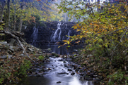
09/18/13 Featured Arkansas Photography–The Natural Bridge in Lost Valley near Ponca Arkansas

The Natural Bridge in Lost Valley near Ponca Arkansas on the Buffalo River–click on photo for a larger view
Taken with a Phase One P45+ in 3 vertical segments to be stitched into one frame, 35mm Mamiya lens, F14, iso50, 3 second exposures with ND filter and CL-PL. Lost Valley is one of my favorite spots in Arkansas to photograph, especially when there is water running in Clark Creek. I would say that in the 100 or so trips I have made to Lost Valley over the years, I have only seen water like that shown in this picture about 10 times. Clark Creek runs throughout Lost Valley and eventually empties into the Buffalo River above Ponca. This one valley has more scenic value packed into the 1.5 miles of trail than most other places in the Ozarks. You can find over 6 separate waterfalls when the creek is running at full flow. If you have not been there before with a good head of water running in Clark Creek, I would put this on your list of places to visit. You can be sure of good water in Clark Creek if the Buffalo River is running over 2000 cfs when gauged on the USGS gauge at Boxley. Lost Valley can also especially pretty in the dead of winter if you happen to catch it after a heavy snow.
09/08/13 Featured Arkansas Photography–Old car along Hwy 123 near Lurton


Old Car along Hwy 123 near Lurton Arkansas–click on image for a larger view
Taken with a Canon 5D MKII, Canon 24-70 lens, F8, iso 100, taken in 5 exposures then blended together in Photoshop. This is a common site in Arkansas along the old farm roads and forest roads throughout the state. Many times the car is sitting on an old home site and was abandoned when the family left. In the background you can see what is left of an old home. I had driven by the old car for years, either on trips to run Richland Creek, or photograph along Sam’s Throne, but never stopped to really photograph it. On this day I like the weeds that had grown up along the side of the car and stopped to shoot it. As the light was waning, I shot this in a 5 exposure bracket then combined the shots. With any old vehicle, I like to add a bit of grunge to help accent the rust patina. On my next trip I made a point of looking for this car was surprised to see that it was gone. Someone had either taken it for scrap or a re-build. I assume scrap as I don’t think it was very rare. Rule of thumb when you see it shoot it.
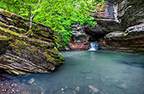
08/23/13 Featured Arkansas Photography–Rocks and Leaves on the Cossatot River
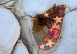

Rocks and Small Pool on the Cossatot River in Southwest Arkansas
Taken with a Canon 1ds MKII, iso 200, Canon 24-70 Lens @70mm, 1/60th of a second. The Cossatot River is one of my favorite spots to hike. You have all sorts of photographic subject matter to work with. The Cossatot River is in the southwestern corner of Arkansas Ouachita Mountains. You can find some of the best photography in the area known as the 6 falls or Cossatot Falls. Here the river turns due south and drops over 6 separate ledges, each of which have unique rapids and names. The rocks around Cossatot Falls are sandstone and have been worn totally smooth by the action of the water. You can find all types of interesting formations, such as the one in the photograph above where lines of quartz are running through the rocks.
08/09/13 Featured Arkansas Photography–Swirls in foam on the Cossatot River

Swirls in foam on the Cossatot River in Southwestern Arkansas
Taken with a Canon 1ds-MKII, Canon 24-70 lens, 24mm, F9 for 1/125 of a sec, iso 100. The Cossatot River has a wide range of photographic subject matter. When the water is running high you can make a trip down to catch the kayakers running Cossatot Falls, and when the water gets lower, you can look for unique spots along the riverbank to work. Most of the rock along the river is sandstone and tends to have a reddish hue in most places. The best place to catch the kayakers is at Cossatot Falls. Here you can perch on one of the rocks for the best view. The falls consist of 6 separate drops and each has a unique name. The most famous drop is the “washing machine” which tends to get the most attention. The only problem with the Cossatot is the fact that it’s about a 3 hour drive from Little Rock so a trip there makes for a rather long day.
Swirls in foam has been printed on both canvas and Canon Platine rag. It makes an excellent print and can be displayed in both the horizontal and vertical orientation.
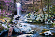
07/25/13 Featured Arkansas Photography–6 Finger Falls on Falling Water Creek
- At July 26, 2013
- By paul
- In Featured Arkansas Photography
 0
0

Six Finger Falls on Falling Water Creek
Taken with a Phase One P45+, Mamiya 35mm F3.5 lens @F14 iso 50 for approximately 1 second. Falling Water Creek is one of the many jewels of Arkansas. This particular spot is one of the more popular spots on the creek. Here you find a ledge that runs all the way across the creek and is broken in 6 spots, thus the name 6 finger falls. The total height is about 10 feet and it’s a very unique spot on the creek. The rocks in the foreground on this shot were all washed away in a recent flood and now there is only a sandbar. The creek above the falls has a long flat bedrock bottom is a nice spot to wade. If you want to photograph 6 finger falls, I would recommend you plan on being there in the morning in the afternoon, the sun will be shinning in your face. Of course if it’s a day like this one, overcast, it won’t matter. This area is about 2 hours away from Little Rock.
07/19/13 Featured Photography–Man and Bear footprints in Alaska
- At July 20, 2013
- By paul
- In Featured Arkansas Photography
- 0
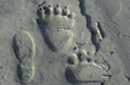

Man and bear in Alaska–Click on image for a larger view
Taken with a Canon Digital Point and shoot in 2000. This photo was taken in Alaska near Lake Lliamna. I was on a one week fishing trip where we were shuttled out to different fishing spots each day. Even though the main focus of the trip was fishing, one of my main focuses was photography. I was using a 8mp Canon point and shoot that looked like the older Canon film Elf cameras. I also had a Nikon D1 along which was my first 35mm digital camera. During the day when I was fishing, I tended to only carry the much smaller Canon camera along. This way back in the ay and I may be wrong on the overall megapixel size, as it may have only be 4mp or 6mp. However it still had a LCD screen for checking the files and it did a very good job overall. Back in 2000 the best possible iso rang would have been around iso 400 and I took this shot in the iso 20o range.
After fishing all morning I was walking back to the plane and following my footsteps out to the river from earlier that morning. About half way back, I found that a large bear had come into the river and then tracked back out along my route. It was pretty impressive to see my size 10.5 shot print (these were actually size 11 wading boots) next to the front and rear paw prints from a full grown brown bear. Needles to say I made the rest of the trip back in double time. I realize this is not a Arkansas shot, but it’s still one of my more favorite shots from the trip to Alaska.
You can read more about Lake Lliamna here:
07/06/13 Featured Arkansas Photography–Winter vista of Sam’s Throne
- At July 06, 2013
- By paul
- In Featured Arkansas Photography
- 0

Winter vista of Sam’s Throne in the Arkansas Ozarks
Taken with a Canon 1ds MKIII, Pentax 35mm FA lens, Zork adapter, iso 100, F11. Sam’s Throne is one of the more iconic spots in the Arkansas Ozarks. It’s geology is also a bit unique in that most of the exposed rocks are sandstone. Sam’s Throne is the large hilltop in the left of the frame. There is a long exposed Bluff line that runs for about 1.5 miles opposite Sam’s and this bluff line is one of the premier climbing spots in Arkansas. I like to work Sam’s throughout the entire year, but this wintertime shot was a rare opportunity. Arkansas had a major snow event the night before and as I got to Sam’s the clouds were just starting to clear. I was blessed with a bright blue sky poking through the clouds and a great coating of snow on everything. It would have been great to be there early in the morning when the trees were still lined with snow. I took this shot in a series 3 vertical segments with a Zork adapter and a Pentax 35mm FA lens and then I stitched the images together. You can get to Sam’s by traveling north on Arkansas Hwy 7 to the Junction with Hwy 123. Stay on Hwy 123 for about 12 miles, the turn off for Sam’s Throne will be on the left.
06/14/13 Featured Arkansas Photography–Fall scene at Gunner Pool Dam
- At June 14, 2013
- By paul
- In Featured Arkansas Photography
- 0

Fall scene at the Gunner Pool Dam–Gunner Pool Campground
Taken with a Canon 1ds MKII, iso 100, Canon 24-70 lens @24mm F8, for approximately 3 seconds. Gunner Pool campground is one of the scenic gems tucked away in the middle of the Arkansas Ozark mountains. This photograph was taken in 2008 in the middle of a wonderfull fall photographic season. The night before it had rained and the small creek that creates gunner pool was starting to run over the top of the dam. Many people feel that gunner pool is in Sylamore Creek, which is right next to this spot, however pool that the campground is named for is the one created by the dam. Sylamore creek is a wonderful spot to camp, and has one of the best campgrounds in Arkansas. It’s always pretty crowded so if you are planning a trip up there in the summer, plan on getting there early and on a weekday if at all possible. The lower 5 campsites at gunner pool are along Sylamore creek and they the best ones. There is also a great swimming spot in Sylamore creek which is bordered by a nice bluff.
06/10/13 Featured Arkansas Photography–Springtime at Cedar Falls on Petit Jean Mountain
- At June 10, 2013
- By paul
- In Featured Arkansas Photography
- 0

Springtime at Cedar Falls on Petit Jean Mountain–Click on image for a larger view
Taken with a Phase One P45+, Mamiya 35mm F3.5 Lens at F14, iso 50, Exposure for approx 1.5 seconds. Here are my print prices if you would like to purchase a print of this photograph My website features many photographs of Cedar Falls on Petit Jean. Petit Jean is about a 40 minute drive from Little Rock and is one of the largest State Parks in Arkansas. It’s not a well known fact that before Hot Springs National Park was created, there was serious consideration to make Petit Jean a National Park instead. Cedar Falls is one of the highest “real” waterfalls in Arkansas. There are many other spots where water will run over a bluff during a heavy rain and create a temporary waterfall, but not many of them flow year round. You can hike down to the base of Cedar Falls from a trail that starts up at the back of Mather Lodge. The trail itself passes many very pretty spots that may warrant a quick stop. This photograph was taken at the peak of spring when the single red bud at the base of the falls is in full bloom. One of the features of Cedar Falls is that there is almost always someone standing around the base of the falls and they tend to be in the way of a good photograph. On this day, I was lucky enough to have the falls to myself for almost 2 hours and that was plenty of time to capture some great images. This photograph was taken with a Phase One P45+ Medium format digital back and a Mamiya 645 camera.
 From the Blog
- Errors with High Resolution Mode, Panasonic LUMIX S1RII July 4, 2025
- 05/08/25 Capture One, big announcement, at least for portrait photographers May 8, 2025
- 05/03/25 Trump’s Tariffs finally start to hit Photography Equipment. May 3, 2025
- Firmware 4.1.0 for X2D? April 21, 2025
- 04/18/25–Looks like Trump’s Tariffs are much ado about NOTHING in regard to photography equipment. April 18, 2025
- 04/09/25 Arkansas Sets new standard for Scientific Ignorance with new law for Ivermectin April 4, 2025