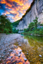
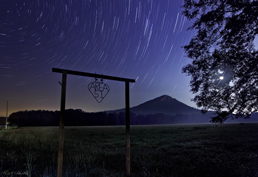
01/04/17 Featured Arkansas Photography–Sunset from Calico Rock on the White River

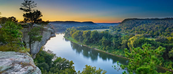
Afterglow from near Calico Rock on the White River in Arkansas.
Taken with a Phase One IQ100 back and Phase One XF camera @ 35mm LS lens, @ ISO 100 Single frame with a lot of push in the shadows.
The view of the White River from Calico Rock is one of the best in the state. Here you have a huge sweeping bend in the river and a beautiful valley that is full of deciduous trees that can produce a wonderful fall color display (however this did not happen in 2016). This spot on the river is just above the town of Calico Rock and you can easily see the town from this spot. I prefer to work this spot in the early morning or late evening. In the late summer to early fall the sun will set just off to the left of the frame and allows for a wonderful afterglow. In the winter and later fall the sun will be too far to the left to be really much of a part of the shot.
If you come to this spot in late May to the end of June the sun will set right over the lone pine tree and will give you a lot more illumination on the river and trees below the bluff. Calico Rock is also a great spot for night photography as there is not very much local light pollution that will effect your shot. However be warned that during most nights, the river fog will quickly rise over the top of the bluff and start to block out your view of the sky. It’s a great thing to watch as the fog starts to build up upstream and then starts to roll down the valley, eventually filling everything up. You will have to continuously watch the front of your lens as it’s very easy for the outer element to fog up.
Just another great spot to spend an afternoon in Arkansas.
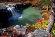
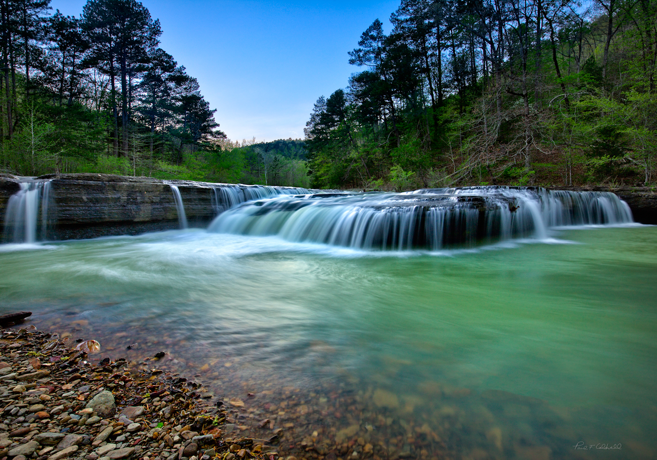
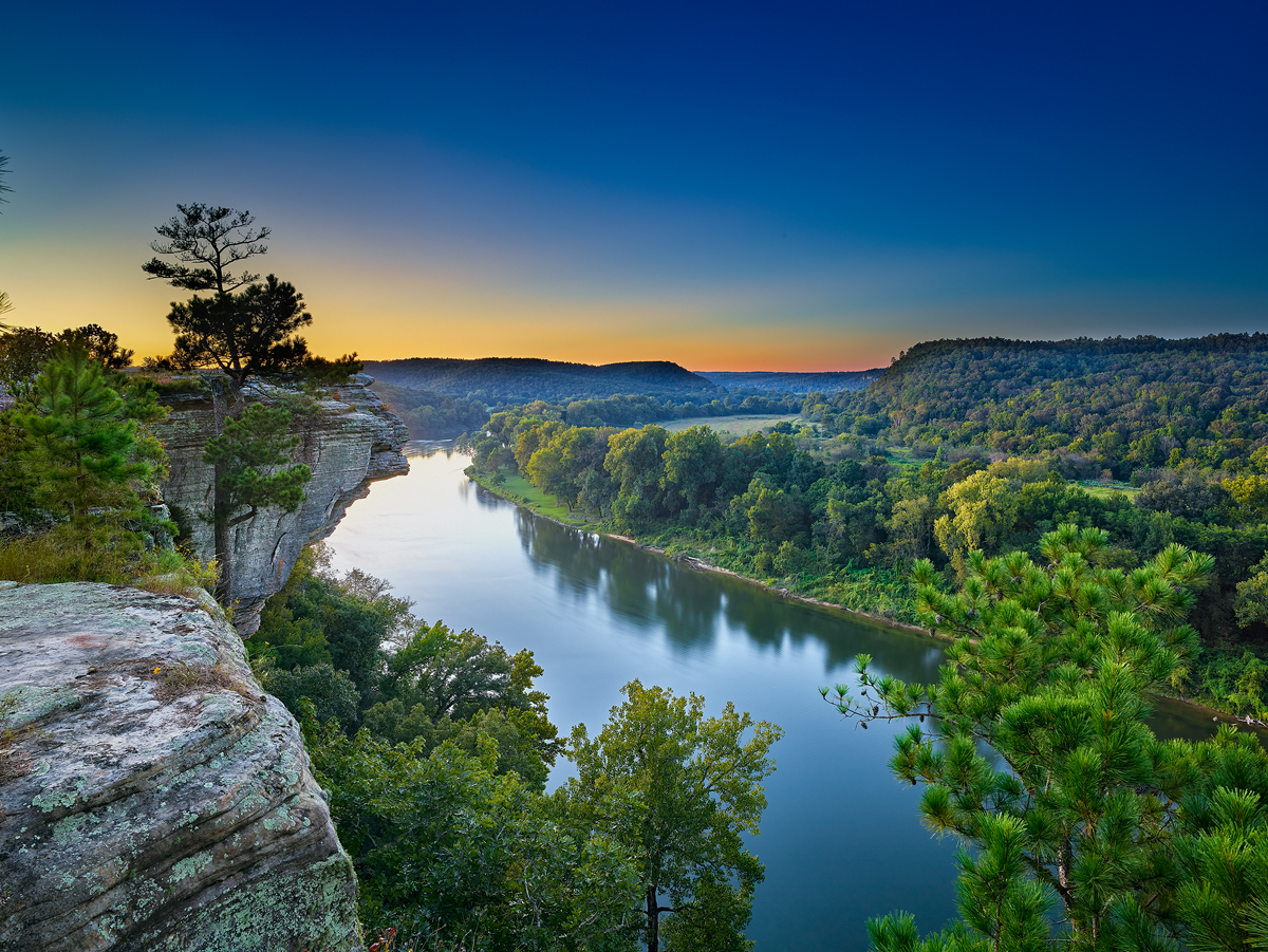
08/21/16 Featured Arkansas Landscape Photography–Storm Clouds over Buffalo Point, Buffalo National River Arkansas

The Buffalo River at Buffalo Point in early August with a morning storm rolling in.
Taken with a Phase One IQ100 and Phase One XF/35LS lens, at ISO 100, F12 for 1/40 of a second on tripod, single exposure.
This was taken back in early August 2016 on the Buffalo River in Northwest Arkansas. This part of the river is known as Buffalo Point, and is one of the more popular spots on the river. It features one of the larger campgrounds on the Buffalo along with hundreds of miles of hiking trails. Within 9 miles of Buffalo Point, you can driver over to Rush Arkansas which is an old mining town which dates back to around 1917. There is not much left standing at Rush, but it still offers some nice hiking.
This image shows just how fast conditions can change. I walked down to the river before sunrise. This particular bluff is on the east side of the river, thus will not get any sunlight until mid day. It’s a great spot to catch a sunset if the clouds lineup, but you also can expect to find hundreds of people wandering around the beach which just add confusion to both the scene and water. On this morning I was hoping to catch the area to myself, and for about a magic 40 minutes I had just that. There was almost no wind blowing, so I also was able to get a very nice reflection of the bluff. This bluff is about 80 feet tall and the face about 35 feet or so and it’s one of the classic Ozark bluffs made 100% from limestone so you can expect to get some interesting color from the rock.
I worked the area up and downstream, but this spot was the best as a early morning storm rolled in. When I first arrived there were no clouds in the sky at all just a bit of river fog, but within 30 minutes the top of an old thunderhead came over the river and really added to the shot. The heat and humidity were intense but the photographic opportunities were excellent.
This is single exposure from an IQ100 Phase One digital back and I have to say that the overall dynamic range of this back is impressive. The ability to finally cover a shot with just one exposure, knowing that you have room to work up shadows without a bracketing series of exposures is a great feature and long overdue from Phase One.
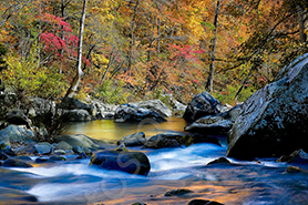
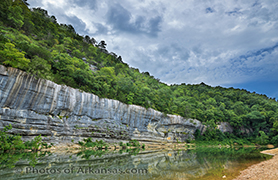
08/20/16 Featured Arkansas Photography–Early morning at Buffalo Point, Buffalo National River
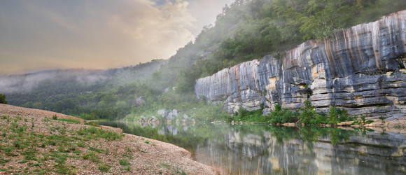

Early mornings are some of the best times to photograph the Buffalo River. This is from Buffalo Point.
Taken with a Phase One IQ100 and 35LS lens, no filters @ ISO 100 for 1/40th of a second F12 and Phase One XF.
While on a trip to the lower Buffalo River, I was able to spend the night at Buffalo Point Campground. This is the first campground that was built on the Buffalo, and dates back to the WPA and CCC days of the late 1930’s in Arkansas. Here you are pretty low down on the river as there is only about 20 or so miles left before the river runs into the White River. Buffalo Point is a very popular spot on the river as it has an excellent campground, and there is a great swimming hole below the large bluff on the far side of the river. From here you can take a quick float down to Rush which is about 8 miles or do down river. It’s a great float to take in the fall to enjoy the fall colors as most often there will be enough water for floating year round.
I was hoping to catch the early morning light burning off the fog but there was only a small amount of fog. However there was a large cloud bank moving in from the west and sun managed to pop the lower clouds along with the fog rising up towards the top of the bluff. I had the place to myself, which on this river is a rare event so I was able to have almost 45 minutes before the first floaters started to come down from Hwy 14 and break up the great reflection on the river.
The Phase One XF and IQ100 worked together very well on this occasion. I was using a tripod due to the slower exposure times and the fact that the 35LS lens is so heavy. The camera controls on the back of the IQ100 LCD made working with this scene very easy. I ended up shooting several manual brackets but due to the impressive dynamic range of the IQ100 sensor, I was able to create this image from one exposure. The 35LS lens performed quite well, giving me excellent details throughout the image.
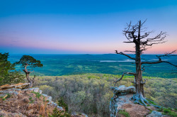
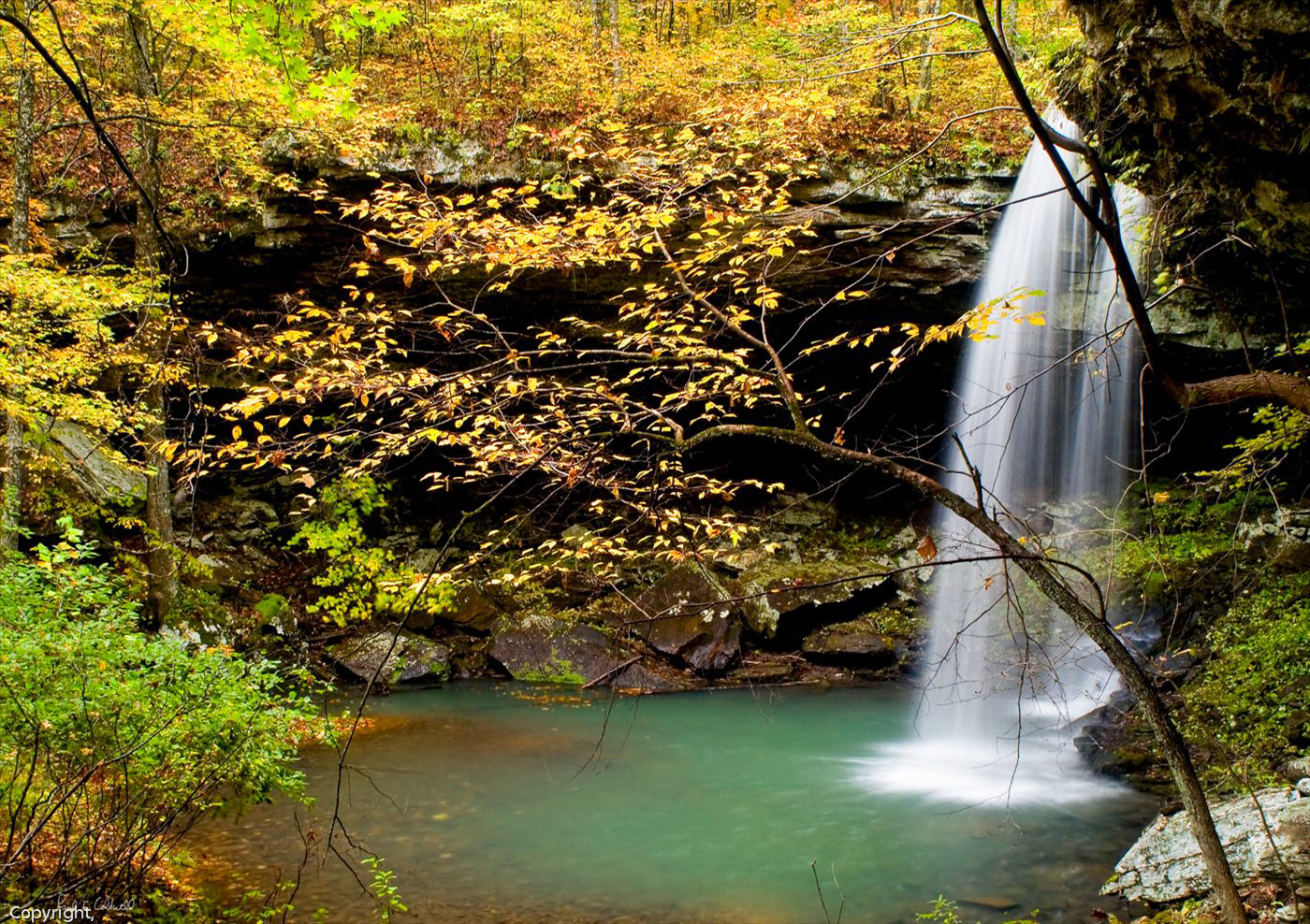
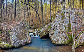
02/05/16 Featured Landscape Photography–Wintertime on White Oak Mountain near Hector Arkansas

PLEASE NOTE: All of the photography of this website is the property of www.photosofarkansas.com and is copy right protected. Do not copy any of the images on this site to paste on Facebook, Pintrest, or any other website without the permission of Paul Caldwell. Years of time have gone into capturing these photographs, please respect that. I do not take copy right infringement lightly. If you have a need to display any of my work on your site ASK me before you Copy & Paste.
Taken with a Phase One XF camera & IQ260, 55mm LS lens and CL-PL. Image is composite of 3 vertical images with the 55LS set to it’s nodal point.
This past winter I started trying to find some new places to photograph in Arkansas. I have worked Falling Water Creek and Richland for years and still love that part of Arkansas, but I felt it was time to move on. I had heard a lot about White Oak Mountain from Chris Kennedy and wanted get a look at the area in winter. If you hike into a spot in Arkansas for the first time, I always recommend coming in winter or early spring as you will see a lot more of the surrounding areas. Later on in summer the trees will hide a lot and the undergrowth makes hiking in general much harder.
White Oak Mountain, is actually a long ridge that runs east and west near Hector Arkansas. To get there, you need to drive to Hector, through the town and as soon as cross a small bridge over a minor creek, you will see a dirt road heading up to the right. Stay on this road for about 7 miles, there will be some turn offs but once you find the right spot, you can hike right down into a great creek valley. This creek has a nice run which offers several nice smallish waterfalls in quick succession. If you hike up the far hillside, you can find some much more dramatic waterfalls, but these will only be running after a locally heavy rain.
What I found most interesting on White Oak mountain was the number large boulders that were just laying in the creek. This reminded me of Richland creek, however the terrain is a bit more open than on Richland.
Once you are done in the creek valley walking is very easy and you can make good headway. There is a RV trail and a marked hiking trail that will take you down to the creek. This creek outwardly appears to be about 1/5 the volume of Richland creek, but the unique geography surrounding the creek makes the hike worth a trip. I would warn anyone that crossing this creek in high water could be a bit dangerous as the bottom is full of large mossy rocks easy to slip on.
I hope to make another trip here in the future to see what the area looks like in Spring with more water running.
To capture this photograph, I used a Phase One XF camera with a IQ260 Medium Format back and 55mm LS lens. The photograph was taken with a nodal panorama setup and I used the captures to make the one horizontal shot. To slow the water down I used ISO50 on my camera and a polarizer. As you can see in the photograph, the light was already marching up the far side of the valley, so I did not need a ND filter. The raw files were converted in Capture One software and then I used PtGui to stitch the 3 images together. I then added a bit of Topaz clarity to my liking.
 From the Blog
- 01/24/24 Sunset over Walton Heights and Pinnacle Valley January 24, 2024
- 01/22/24 Looking through the Keyhole on Roark Bluff–Autumn January 23, 2024
- 01/14/24 Sunset from Pinnacle Mountain Little Rock, AR January 12, 2024
- 01/14/24 Winter View of Pinnacle Valley January 12, 2024
- 01/12/24 Fall Scene, Pinnacle Mountain January 11, 2024
- 01/11/24 Hasselblad XCD Camera lenses, all out of stock? January 11, 2024